Services
Tile API
The following sections present the tile API, from the principles of tiling to the use-cases.
Principle
The tile API allows requests of raster data at any scale, following the WMTS grid standard (see specification here).
This EPSG:4326 raster grid is divided into different levels. Each grid level has a fixed spatial resolution, and is subdivided into tiles of 256 per 256 pixels horizontally and vertically. Any raster product supported by the VtWeb Framework can be requested using this service.
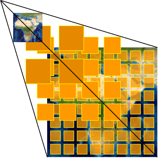
The tiles of each product are organized into a tile-pyramid. This tile-pyramid ensures a fast access to any level of the grid, which allows on-the-fly processing of raster products at any scale (see figure below).
Specifications
The resolution and number of tiles per level is summarized by the following table.
| Level | X tile number | Y tile number | Resolution (°)* | Resolution (m)* |
|---|---|---|---|---|
| 0 | 2 | 1 | 0.703125 | 78271.51696 |
| 1 | 4 | 2 | 0.3515625 | 39135.75848 |
| 2 | 8 | 4 | 0.17578125 | 19567.87924 |
| 3 | 16 | 8 | 0.087890625 | 9783.939621 |
| 4 | 32 | 16 | 0.043945313 | 4891.96981 |
| 5 | 64 | 32 | 0.021972656 | 2445.984905 |
| 6 | 128 | 64 | 0.010986328 | 1222.992453 |
| 7 | 256 | 128 | 0.005493164 | 611.4962263 |
| 8 | 512 | 256 | 0.002746582 | 305.7481131 |
| 9 | 1024 | 512 | 0.001373291 | 152.8740566 |
| 10 | 2048 | 1024 | 0.000686646 | 76.43702829 |
| 11 | 4096 | 2048 | 0.000343323 | 38.21851414 |
| 12 | 8192 | 4096 | 0.000171661 | 19.10925707 |
| 13 | 16384 | 8192 | 8.58307E-05 | 9.554628536 |
| 14 | 32768 | 16384 | 4.29153E-05 | 4.777314268 |
| 15 | 65536 | 32768 | 2.14577E-05 | 2.388657134 |
| 16 | 131072 | 65536 | 1.07288E-05 | 1.194328567 |
| 17 | 262144 | 131072 | 5.36442E-06 | 0.597164283 |
| 18 | 524288 | 262144 | 2.68221E-06 | 0.298582142 |
| 19 | 1048576 | 524288 | 1.3411E-06 | 0.149291071 |
| 20 | 2097152 | 1048576 | 6.70552E-07 | 0.074645535 |
| 21 | 4194304 | 2097152 | 3.35276E-07 | 0.037322768 |
| 22 | 8388608 | 4194304 | 1.67638E-07 | 0.018661384 |
Request
Base URL
The base URL of the tile API is the following.
https://visioterra.org/VtWeb/servlet/TileServletParameters
This service requires the following parameters.
| Parameter | Description | Example of value |
|---|---|---|
| MODULEID | Name of the module of interest. | VtSentinelMSI |
| DATASETID | Name of the dataset of interest. | Sentinel2A/MSIL2A |
| GRANULEID | Name of the granule/product of interest. | S2A_MSIL2A_20210902T154911_N0301_R054_T18TWL_20210902T215738 |
| STYLE | A POF-ML script to be applied to the data. | rgb(sta(QT_B04,HT_B04,0.02,0.02),sta(QT_B03,HT_B03,0.02,0.02),sta(QT_B02,HT_B02,0.02,0.02)) |
| X | The horizontal coordinate of the requested tile. | 2412 |
| Y | The vertical coordinate of the requested tile. | 1119 |
| Z | The level of the requested tile. | 12 |
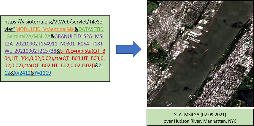
Example
In the request section, the following parameters are given as example:
MODULEID = VtSentinelMSI
DATASETID = Sentinel2A/MSIL2A
GRANULEID = S2A_MSIL2A_20210902T154911_N0301_R054_T18TWL_20210902T215738
STYLE = rgb(sta(QT_B04,HT_B04,0.02,0.02),sta(QT_B03,HT_B03,0.02,0.02),sta(QT_B02,HT_B02,0.02,0.02))
X = 2412
Y = 1119
Z = 12
By using the base URL of the tile API and these parameters, the following request can be built:
https://visioterra.org/VtWeb/servlet/TileServlet?MODULEID=VtSentinelMsi&DATASETID=Sentinel2A/MSIL2A&GRANULEID=S2A_MSIL2A_20210902T154911_N0301_R054_T18TWL_20210902T215738&STYLE=rgb(sta(QT_B04,HT_B04,0.02,0.02),sta(QT_B03,HT_B03,0.02,0.02),sta(QT_B02,HT_B02,0.02,0.02))&Z=12&X=2412&Y=1119This request returns the following Sentinel2A tile: